The SWPPP record, built as you walk. Not rebuilt at your desk.
Drop pins on the plan, capture geo-tagged photos, and leave with an NPDES-ready, digital SWPPP report. Whether it's a routine walk or a post-storm check, the record gets built on-site.
Trusted by the best


The real problem
Most SWPPP failures aren't from missing work. They're from missing records.
The inspection ends up scattered: notes typed up from memory, photos with no location, corrective actions buried in text threads. A missed observation or an undated photo can turn into a delay, a fine, or a failed audit.
$62,947
maximum daily penalty per violation under the Clean Water Act. Fines accrue every day until the violation is documented as resolved.
7-14 days
the EPA inspection cadence required by most NPDES permits, plus a separate inspection within 24 hours of every qualifying rain event.
$3.7M
paid by a single California developer for SWPPP violations, even with a Pollution Prevention Plan in place. The plan existed. The record didn't hold up.
The SiteMarker SWPPP workflow
Run the inspection once. End with the record done.
Every step happens on-site, on the map, in the order an inspector actually walks the project. The record is finished when the walk is finished.
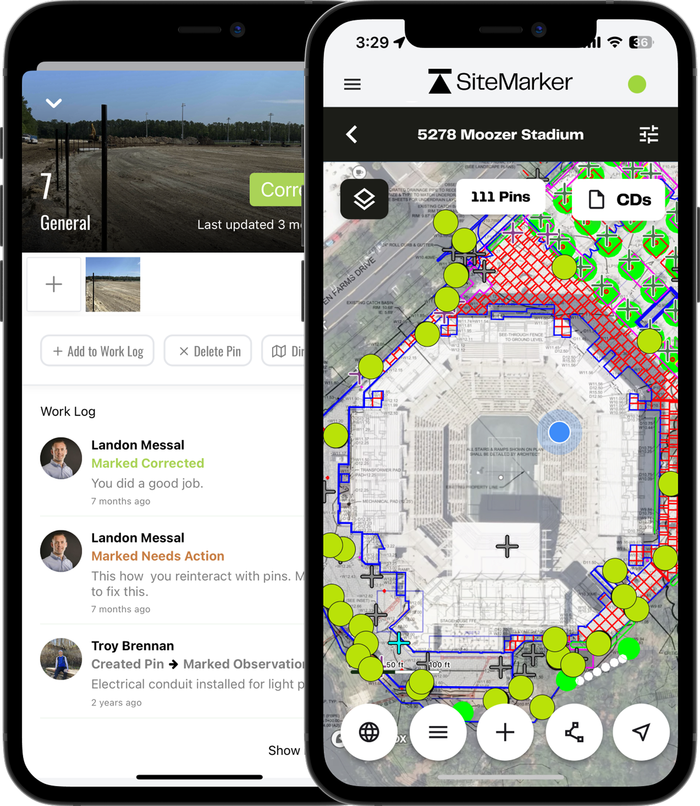
Locate
Load SWPPP and erosion control drawings on the map. Every silt fence, sediment basin, and inlet protection gets pinned at its real coordinates.
Document
Tap a pin, attach photos, dictate or type notes. Each observation carries its location, timestamp, and inspector. No camera-roll triage later.
Report
Generate an NPDES-formatted report straight from the field. Photos, notes, locations, and signatures organized in seconds. No Word template, no copy-paste.
Resolve
Assign corrective actions with the location attached, then track them to close-out. The full history stays on the project for the life of the permit.
Built for the walk
Every tool a SWPPP inspector needs, anchored to the plan.
Plans Loaded on the Map
Overlay SWPPP, erosion control, and construction drawings as a live map layer. The plan moves with you as you walk.
Photos Tied to a Pin
Every photo carries the GPS location it was taken at, the time it was captured, and the inspector who took it. No more orphaned camera-roll shots.
Pin-Drop Inspections
Log a Best Management Practice (BMP), a violation, or a corrective action in seconds. Location, photo, and note captured in a single tap.
Corrective Actions, Assigned
Push action items to the responsible contractor or consultant with the location attached. Track them to close-out without losing them in a text thread.
NPDES-Ready Reports
Generate a formatted inspection report from the field. Photos, notes, locations, and signatures organized exactly the way regulators expect to see them.
Offline-Capable
Run a full inspection in a dead zone. Everything syncs the moment you have signal again. No retyping, no lost photos.
Integration
Rain data, automatically attached to every inspection.
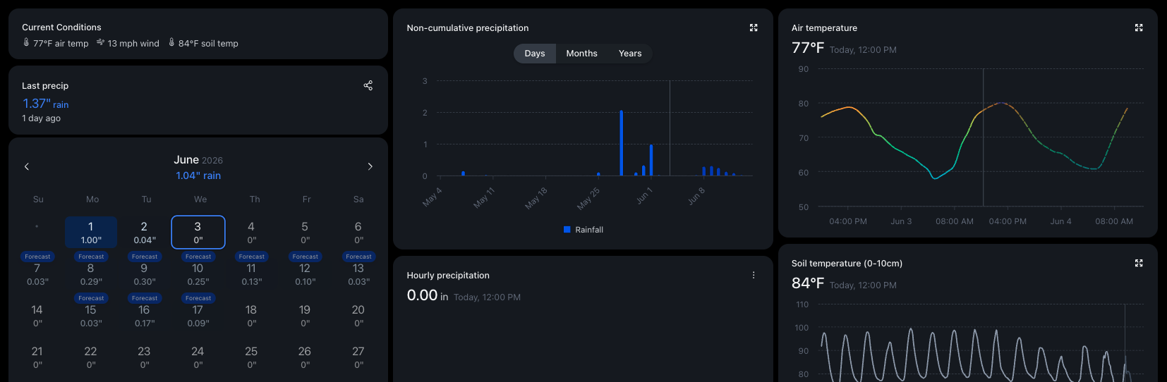
SiteMarker pulls hyperlocal precipitation data tied to your project's GPS coordinates and adds it straight to your inspection reports. Every qualifying rain event is flagged against your permit threshold (0.25" or 0.5"), so post-storm inspections never get missed and rainfall totals never need to be guessed.
From field to record
One record, used by everyone on the project.
A single source of truth for everyone.
Portable PDF reports
Generate a regulator-ready PDF with photos, locations, observations, and corrective actions in one document. Drop it into Procore, ACC, a project SharePoint, or send it straight to the regulator.
Live map, shared by link
Send a link and the project owner, regulator, or contractor sees the live inspection map, pins, and photos in their browser. No login, no software install, no waiting on the next report.
Per project, unlimited users
Inspectors, general contractors, subcontractors, consultants, agency reviewers: everyone on the same map at no extra cost. Pricing is per project, not per seat, so the team is never pruned to fit a license count.
In their words
From the teams running this kind of work every day.
The data we're pulling from SiteMarker is my reporting. It's like here's proof we're doing a great job, on a silver platter, without having to answer a hundred follow-up questions from the board.
Jason Quick
Construction Inspection Supervisor
BJWSA
I can literally have all that in report form and can show them exactly where I have that issue. It's almost hard to quantify the time because it's so quick.
Earl Bailey
Construction Manager
Lennar
Weekly site visit reports used to be a significant lift. Having the documentation already collected in the field, with photos attached and locations logged, cuts that process down considerably.
Ismail Jallaq
Project Management
K. Hovnanian Homes
SWPPP Inspection FAQs
The questions inspectors, general contractors, and consultants ask before they switch.
What actually makes a SWPPP inspection record defensible?+
A defensible record ties every observation to a location, a timestamp, a photo, and the person who logged it, with a clear corrective-action trail showing what was found and how it was resolved. SiteMarker captures all of that as the inspection happens, so the record stands up to a regulator, an attorney, or an internal auditor without anyone reconstructing it from memory.
Will the reports satisfy our NPDES permit requirements?+
Yes. Reports are organized around the elements regulators expect: BMP location, condition, photo evidence, corrective actions, dates, and inspector identification. Output is a clean PDF you can submit, attach to the project SWPPP binder, or push into Autodesk Forma as part of the permanent record.
How does SiteMarker handle inspections after a qualifying rain event?+
Rain-event inspections work the same way as routine ones, with rain-event-specific fields on the report. Run the walk, pin observations, document any displaced controls, log corrective actions, and the dated report is ready before you leave. There is no separate workflow to remember.
What happens if we lose cell service in the middle of an inspection?+
Nothing stops. SiteMarker runs the full inspection offline: load the plan, pin BMPs, capture photos and notes, generate the report. When the device gets signal again, everything syncs automatically. Inspectors working remote sites or basement levels rely on this every day.
How is this different from a fillable SWPPP form in goCanvas, iAuditor, or a PDF?+
Fillable forms digitize a paper checklist. The inspector is still typing field values disconnected from any map or spatial context. SiteMarker is map-first: every observation is pinned to the actual control on the actual plan, so location is captured automatically and the report shows exactly where each issue was found. That is the part regulators and contractors actually argue about.
How does pricing work when multiple contractors and consultants need access?+
Pricing is per project with unlimited users. Inspectors, general contractors, subcontractors, consultants, and even agency reviewers can all be on the same project map without adding cost. The economics do not punish you for putting the right people on the record.